Wilson-Bates Furniture Co.

The Wilson-Bates Furniture Store, constructed c. 1906, was originally operated as the Graham Mercantile Company. Prior to construction, the building was described as “43 feet and four inches by 101 feet running back to Graham alley, back of Aultman street. It will have a basement under the entire building and will be put up with brick to a height of two stores; however, the building appears to have been constructed as a three-story building and is listed as such on the Assessor’s site.” The building was constructed on the same property as the previous Graham Mercantile Company.

Wilson-Bates Furniture Co., c. 1930s.
Graham Mercantile Co. advertisement from White Pine News (1906).
Wilson-Bates Furniture Co., c. 1930s. Note the Italianate style and stone exterior.

The name of the business changed to Campton Commerce Company in 1920 and eventually became Wilson-Bates Furniture Company. The building was constructed in the Italianate style with a wide-eave overhang supported by decorative brackets on the front façade. The 1907 Sanborn maps show the building to be a two-story, brick building with a frame cornice. The rear elevation is shown as having windows on both the first and second story. The second story windows appear to have been covered when metal panels were applied to the exterior. Additionally, the building is shown to have possessed a skylight on the second story, an elevator, a furnace, and a fire protection system (fire-proof walls and two hydrants with a 50-foot and 100-foot hose). Aerial photographs show the skylight to no longer be extant. The 1912 Sanborn maps show the same layout; however, the west elevation now shares its first-story wall with the building direct to the west (333 Aultman Street). A fire-door passageway between the two buildings is also shown. The 1923 Sanborn maps show the same building; however, it is now labeled as Campton Commerce Co.

1907 Sanborn map for Ely showing the footprint for the Graham Mercantile Co.
1912 Sanborn map for Ely showing the footprint of Graham Mercantile Co. and the building next door.
1923 Sanborn map with the building labeled as Campton Commerce Co.

William Boggs Graham was a local businessman and mine owner in the White Pine area. Born in August 5, 1854 in Pennsylvania and married to Katharine (1886), Graham is credited as keeping the town of Ely afloat in its early days by furnishing miners supplies on credit since the 1870s. He arrived in the area around 1874 and quickly established himself. He served as postmaster for the town of Ely from 1889 to 1894 and 1901 to 1907, as well as serving as the President of the White Pine County Bank, located directly next door to the mercantile. He was also a member of the state banking board, having been appointed by Governor Oddie. Much of the material used to construct the early buildings of Ely was supplied by Graham. The 1910 Federal Census has his address listed as 376 High Street in Ely, Nevada and 379 Aultman Street in 1920. Graham moved to California sometime after 1920 and died in 1924.

Sources used for this article include the following:

“Graham Mercantile Co. is Incorporated.” 1906. White Pine News, May 11.

Ancestry.com. U.S., Appointments of U. S. Postmasters, 1832-1971 [database on-line], accessed on April 6, 2020;

“Appointments Made Yesterday Evening: W.B. Graham of Ely, J.A. McBride of Elko and Hugh Brown of Tonopah.” 1911. Reno Evening Gazette, March 28.

“News from the State Press.” 1906. Reno Evening News, October 6.

1886. White Pine News, January 30.

United States Department of Commerce: Bureau of Census, 1910.

“The Nevada Rambler.” 1934. Nevada State Journal, August 18.

Research Pays Off

I recently co-authored an article with some folks from the illustrious CRM firm Mead & Hunt. The issue (TR News 318) will come out next month and will be posted to the TRB website in four months. But for now, you can read it here:

Streamlining Survey in Reno’s Spaghetti Bowl

TR News is copyright, National Academy of Sciences, Engineering, and Medicine; posted with permission of the Transportation Research Board.

BUNKERS at Guantanamo Bay, Cuba

A bunker is typically part of a military fortification and can mostly be found on coastal fortifications. Guantanamo Bay has several styles of bunkers that were built during World War II and the Cold War.

World War II Bunkers

World War II Bunker at Facility 549 at Guantanamo Bay built in 1942 (A. Thomas).

Bunkers built during World War II were typically built using hexagonal (six-sided) plan. Structural features include a flat roof with a slight drip edge, board-formed poured-concrete walls and roof, a small steel-door entrance, and a narrow horizontal viewing window (roughly six inches wide) that encircles the entire structure. The viewing window gave occupants an unimpeded view of the entire bay.

World War II bunker located on Hospital Kay at Guantanamo Bay, Cuba (A.Thomas).

Cold War Bunkers

A 2003 update to Rear Admiral Murphy’s 1953 History of Guantanamo Bay discusses the Cuban Missile Crisis of 1962.  In June of 1962, Mobile Construction Battalion Four, or “Seabees,” was deployed to Guantanamo Bay for training. When the Missile Crisis started in October, the Battalion was still at Guantanamo Bay and was put to work upgrading the base’s defenses. The Seabees, with some assistance, built over 20 miles of new roadways during the first two weeks of the crisis. They also built hundreds of reinforced-concrete bunkers throughout Guantanamo Bay.

Bunker No. 1 (A. Thomas).

Bunker No. 1 is constructed using Concrete Masonry Unit (CMU) construction with a flat steel roof. The building is set into the hillside, so that half of the building is underground. The building has openings on each side so that the view is unobstructed.

Bunker No. 2 (A. Thomas).

Bunker No. 2 has an arched corrugated metal roof and CMU walls.  The building is set into the hillside, so that half of the building is underground.  The facade set into the ground has a view of the bay. Opposite that is an open doorway.

Bunker No. 3 (A.Thomas).

Bunker No. 3, when in use, concealed vehicles or large artillery. It is constructed with large boards for the roof and sides. The earth has been built up around three sides of the structure with sand bags and then covered with brush, likely to camouflage the structure with the surrounding landscape.

Bunker No. 4 at Guantanamo Bay (A.Thomas).

Bunker No. 4 is constructed using large boards for the roof and sides. The roof has been covered using sand and brush, likely to camouflage the structure with the surrounding landscape. The building is set partially underground, similar to other bunkers of this era. There are openings on one side to give occupants an unobstructed view.

Hidalgo Viego Historic District

Former Post Office of Hidalgo, Texas (1839) (A. Thomas).

The Hidalgo Viego Historic District, or Old Hidalgo, is located in Hidalgo, Texas. The district consists of six buildings from the late 19th century and include the Old Hidalgo County Courthouse and jail (1886), Post Office (1839), the Rodriguez Store (1890), the Odell Store (1889), and the Rodriguez Pioneer House.

Handmade bricks from Reynosa, Mexico (A. Thomas).

The former Post Office is constructed with handmade, fired bricks from the brickmason Juan Rios in Reynolsa, Mexico. The building appears to have a flat roof with a continuous parapet and a brick entablature with decorative brick dentils. The walls are done in the English bond system with alternating of headers to every five stretchers. The other five buildings were constructed in a similar fashion, likely using the same handmade bricks.

Weathering and decay have caused voids between the brick units (A. Thomas).


Marine Monument at Guantanamo Bay, Cuba

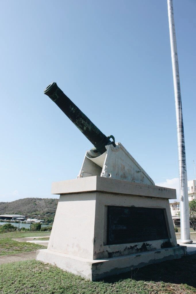
Spanish-American War Monument at Guantanamo Bay, Cuba (A.Thomas).

The monument is labeled as Facility 549.

The base of the monument contains a plaque that reads:

COMMEMORATIVE

OF A

BATTALION OF UNITED STATES MARINES

UNDER THE COMMAND OF LIEUTENANT COLONEL ROBERT W. HUNTINGTON

WHICH DISEMBARKED AT THIS POINT JUNE 10, 1898 THE FIRST UNITED STATES

ARMED FORCE LANDED ON CUBAN SOIL

AND OF

ACTING ASSISTANT SURGEON JOHN BLAIR GIBBS, U.S. NAVY, PRIVATE WILLIAM DUMPHY, U.S. MARINE CORPS

ACTING SERGEANT MAJOR HENRY GOOD, U.S. MARINE CORPS, PRIVATE JAMES MCCOLGAN, U.S. MARINE CORPS

SERGEANT CHARLES H. SMITH, U.S. MARINE CORPS, PRIVATE GOODE TAURMAN, U.S. MARINE CORPS

HERE KILLED IN ACTION WITH SPANISH TROOPS

The cannon is a bronze muzzle-loading cannon that measures 13.7 feet long and is 18 inches wide at the breech. An inscription along the base ring of the cannon indicates that it was made in by a person named Maritz in 1748. Jean Maritz Sr. developed a new way of constructing bronze cannons in 1740. Molten metal was generally poured into a form around a spindle. This created the hollow bore. Maritz Sr. cast the cannon as solid bronze, laid the cannon horizontally, and then drilled the bore into the metal. This led to greater accuracy and safety, as the bore was perfectly centered in the weapon and there was a uniform thickness of metal on each side of the explosion. Drilling the bore reduced air resistance and a smaller explosive charge could propel the same projectile. Jean Maritz Sr. died in 1743, so the this cannon was likely designed and built by Jean Maritz Jr.

Up until the early 1730s, there were no cannon manufacturing standards and every manufacturer produced cannons according to their own standards. This meant that lengths, proportions, and calibers could vary from manufacturer to manufacturer. In 1732, General Jean-Florent de Valliere, a general in the French army, established guidelines for the manufacture of cannons and reduced the number of patterns and calibers of cannons to 4, 8, 12, 16, and 24 pounds. He standardized lengths, proportions, weights, and the methods of manufacture. He required that each breech of the calibers of cannon have a different face. The breech of a 4-pound cannon had a sunburst on it; the breech of an 8-pound cannon depicted a monkey’s face; the breech of a 12-pound cannon had a rooster face; the breech of a 16-pound cannon had the face of Medusa; and the breech of the 24-pound cannon had the face of Bacchus (the Greek god of wine) depicted on it. The breech  molding of the McCalla Hill Cannon has the face of Bacchus depicted on it, surrounded by leaves, and has a large knob protruding from its mouth, forming the cascabel.

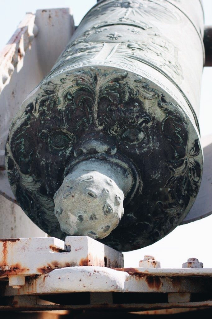
Twenty-four-pound cannons have the face of Bacchus depicted on the breech molding (A.Thomas).

The muzzle is decorated with leaves. At the top of the chase, is an inscription that reads “le Bourbon,” possibly indicating that this cannon was named “The Bourbon.”  Below is the motto “Ultima Ratio Regum” which means “The Last Argument of Kings.” Below that is an inscription, which reads “Louis Charles de Bourbon, Comte d’Eu, Duc D’Aumale,” possibly meaning the cannon was dedicated to Louis Charles du Bourbon, Count d’Eu and Duke of Aumale, who served as the head of French artillery from 1736 to 1755. Below that, and just above the reinforcing ring, is the detailed raised crest of Louis Charles de Bourbon, with three fleur-de-lis, leaves, stars, flags, banners, and cannons, under a crown.

The top reinforce ring is covered in flowers and leaves. The second reinfornce of the cannon has a plain trunnion and two handles carved like sea serpents. At the top of the first reinfornce is an inscription that reads “Nec Pluribus Impar, ” which translates to “Not Unequal to Many” above a sunburst. This inscription, together with a sunburst, was the emblem of Louis XIV, the “Sun King” of France. Below that is the detailed crest of Louis XIV. The first reinforce vent is still open and is surrounded by flames. The edge of the breech has the maker’s mark, indicating that Jean Maritz manufactured it in 1748 in Douai, France.  The trunnion indicates that the cannon weighs 5,730 livres (medieval French pounds), which translates to 6,184 pounds by today’s standards.

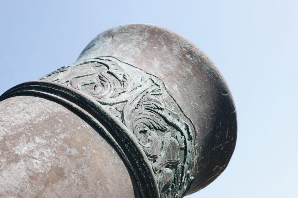
The top ring is covered in raised flowers and leaves (A.Thomas).

There is very little information on how the cannon came to Guantanamo Bay. It may have came to Cuba as early as the French and Indian War (1757-1763), as Spanish King Charles II tried to come to the aid of his cousin French King Louis XV. The American Revolution was another opportunity, when a combined French and Spanish force attacked Pensacola in 1781. Another possibility is that it was brought to Cuba by French forces fleeing from the revolution in Haiti (1791-1804). It could have even come to Cuba as late as 1808-1815, when Napoleon controlled both Spain and France.

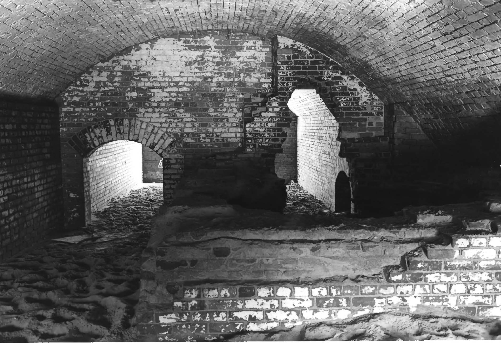
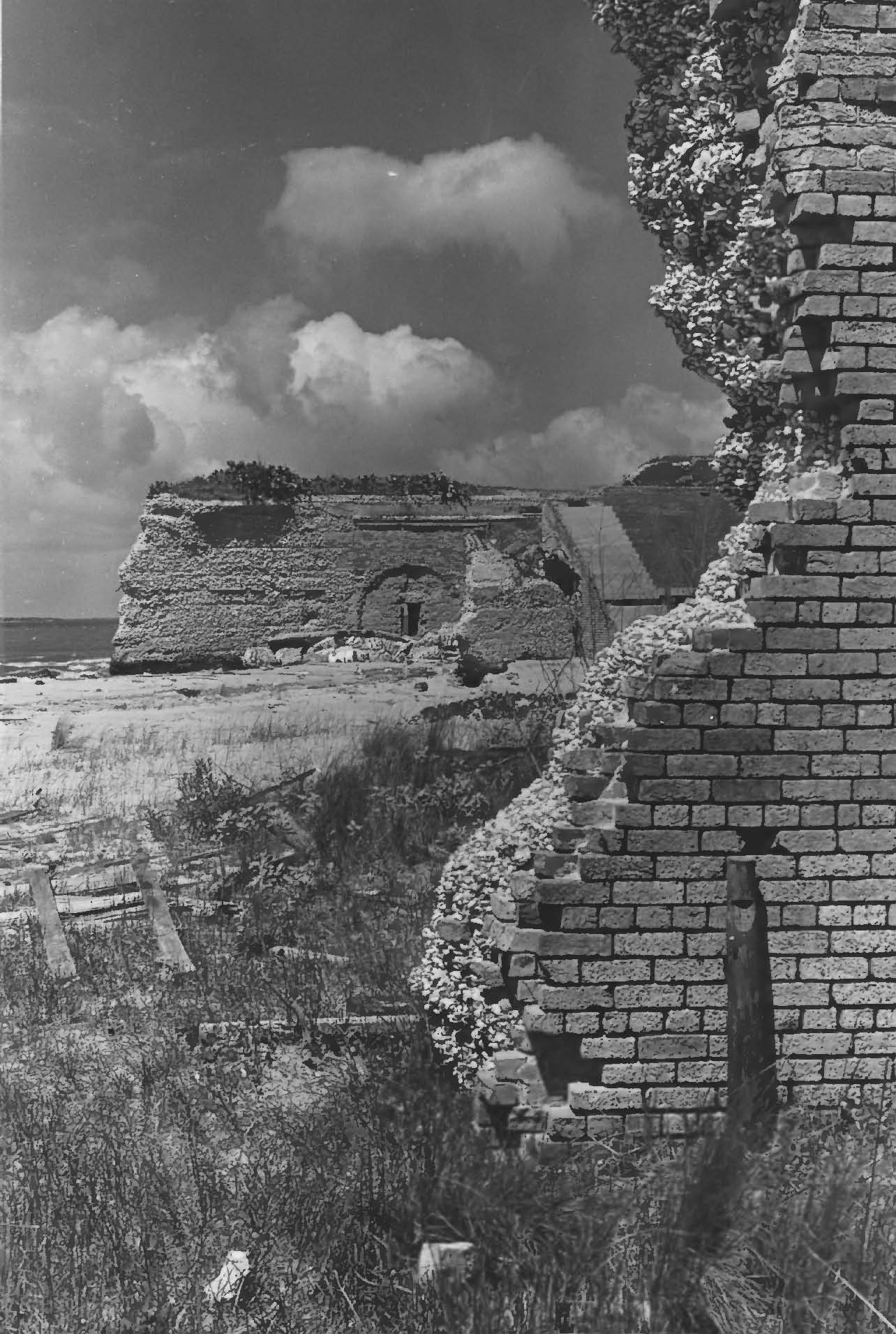
Once the cannon was in Cuba, it most likely came to Guantanamo Bay from Fort Toro, which was a Spanish fortification in the northern portion of Guantanamo Bay. The Fort was thought to have had six muzzle-loaded cannons at its disposal and frequently fired at U.S. Navy ships in the Bay. As the Spanish-American War ended in 1898, the American military began to collect various antique weapons to take home as war trophies, and the Navy requested three of the cannons from Fort Toro be brought to the U.S. Naval Academy at Annapolis. Before those weapons could be collected, however, the store ship Glacier (AF-4) landed and confiscated weapons described as “two of the finest pieces of bronze cannon.” Tipped off by the British Consul, the Commander of Guantanamo went to investigate. When detained, the captain of the Glacier stated that he was collecting the weapons for the Secretary of the Navy, but refused to say if he was under direct orders to do so.  It is possible that during this time, the Commander of Guantanamo Bay had confiscated the two cannons and was awaiting further orders. The monument was dedicated to the Marines who lost their lives in the Battle of McCalla Hill, in February of 1906.

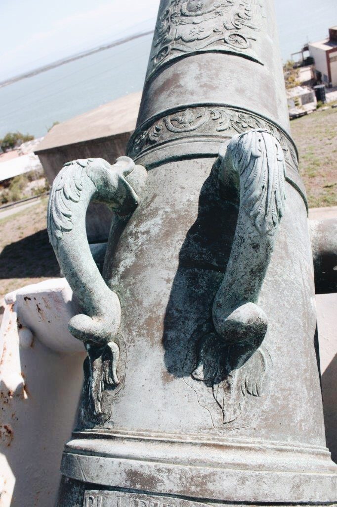
The first reinforce of the cannon is rather plain with two handle shaped like sea serpents (A. Thomas).

In the October 24, 1908 edition of the Army and Navy Register, a display of trophies from the Spanish-American War is described outside of the State, War, and Navy Building in Washington, D.C. (now the Eisenhower Executive Office Building). Among the trophies described is one cannon made by Jean Maritz, and it appears to be a sister to the McCalla Hill cannon. It reads: “It strikes one as odd, for instance, to come across an old French cannon, such as the one captured at Santiago in 1898, and which was made at Douay (sic), France, in 1748, by one Jean Maritz. It is a gem of bronze work and bears all sorts of emblems, decorations and insignia, including its title ‘Le Farouche’ (The Fierce), its Latin motto, an emblem of the House of the Bourbons, the French crown, the French coat of arms, the motto of Louis XIV, and a blazing sun. It is altogether ornate for an instrument of destruction, proud of its ferocious title.”

For more information:

Guantanamo Bay Gazette

Army and Navy Register – October 24, 1908


Manuel Guerra House and Store

The Manuel Guerra House and Store was designed and constructed by Heinrich Portscheller (1878-1884) (A.Thomas).

The Manuel Guerra House and Store was constructed between 1878 and 1884. It was designed and constructed by Heinrich Portscheller, a German architect. The building has a commercial retail space on the first floor and residential space on the second floor. A warehouse runs along the back of the building.

The principal entrance to the structure is at the corner of the Plaza and Hidalgo Street, and the corner of the structure is cut to accommodate the double-door entrance.  This doorway is flanked by brick pilasters set on the low plinth base. The pilasters support molded brick cornice. In addition to the corner entrance, there are five other double-door entrances on the first floor of the structure. These openings have brick flat arches with a small molded brick cornice above.

On the upper level, a cast-iron balcony with repetitive panels of intricate lack-like filigree surrounding the plaza facade and the Hidalgo Street facade. The alternating windows and doors are framed by a composition of flanking pilasters and molded brick entablatures similar to the main entrance on the ground floor.

The building is crowned by a cyma recta cornice with a fillet and dentil course of brick.

Lighthouse at Guantanamo Bay, Cuba


Photos by Alexis Thomas.

The south elevation. The Keeper’s cottage can be seen in the background (A. Thomas).

The weather vane bears an “N” for north, an “S” for south, an “E” for east, and an “O” for oeste (the Spanish word for “west”) (A.Thomas).

The lighthouse at Guantanamo Bay, Cuba is labeled as Facility 831.

Built on a circular plan, the cast-iron lighthouse was constructed in 1903. The tower is 60 feet tall. The original lamps were whale oil lamps that were used until the 1920s when they were replaced by electric lights.  In the mid-1960s the lens, prisms, and the mechanism for making the light revolve were removed and put on display at the U.S. Coast Guard Academy in New London, Connecticut. Structural features are steel panels and six steel support braces, window bays with steel security bars, steel louvered storm shutters, a molded copper cupola and weather vane, and a tongue-and-groove mahogany interior. The lighthouse is five stories and has a steel frame. According to base historians at Guantanamo Bay, the  lighthouse was constructed in New York and shipped in parts to the island.

The roof is a molded copper cupola and  with a copper weather vane. The cupola is molded copper, as is the weather vane. The weather vane bears an “N” for north, an “S” for south, an “E” for east, and an “O” for oeste (the Spanish word for “west”). The windows are steel security bars and steel louvered shutters.  The only door is steel, as is the walkway. There is a significant amount of deterioration in the form of rust and structural damage on all elevations, as well as the walkway and its railing.

According to the U.S. Coast Guard, the use of cast iron in lighthouse construction began in the late 1830s or early 1840s. The perceived advantages were that it was light compared to brick or stone, inexpensive, strong, water tight, and had a slow rate of deterioration. They were more adaptable to coastal areas where a relatively light pile structure was required due to mud, sand, swamp, or coral. Another example of cast-iron lighthouses is Brandywine Shoals off the coast of Delaware.

The walkway shows significant deterioration. All window bays have steel safety bars and steel shutters (A. Thomas).

Steel door at the base of the lighthouse on the south elevation (A. Thomas).

Gilded Age Grand Isle Resorts – The Ocean Club Hotel

The Ocean Club hotel was a two-story building constructed with a E-shaped floor plan. It had 160 room, two parlors, two dining halls, a billiard hall, a card room, a reading room, pantries, kitchen, and a laundry.  The building had nearly 320 gas lights.  The porch, which ran along the entire exterior, was supported by 300 pilings. The middle “E” section of the building were suites for the hotel’s stockholders.  The hotel was apparently built for an estimated $100,000.  It was severely damaged in the 1893 hurricane and, subsequently, abandoned.

Ocean Club Hotel

The gallery of the Ocean Club Hotel facing the Gulf of Mexico (New Orleans Public Library).

Ocean Club Hotel

The south elevation of the hotel. The structure in the middle were suites (New Orleans Public Library).


Whiting Field

One of four water towers at Whiting Field. “Fly Marines” is painted on the side of the water tank (A. Thomas).

Naval Air Auxiliary Field (NAAF) Whiting Field was commissioned on July 16, 1943. At the time, most of the base was still under construction. The airfield was named after Captain Kenneth Whiting, champion of the aircraft carrier. It is rumored that he learned to fly from Orville Wright. Captain Whiting was stationed at Naval Air Station Pensacola and was in charge of developing the first aircraft carrier, in addition to developing aircraft arresting gear and the Landing Signals Officer position. Whiting died at the National Naval Medical Center in Bethesda, Maryland, after a short hospitalization in April of 1943 (Southeastern Archaeological Research, Inc. [SEARCH] 2014).

RADAR tower located at Whiting Field (A.Thomas).

At the time of its commission, Whiting Field was the largest of the auxiliary fields around Pensacola.  It had a south and a north field. Each field had four asphalt runways that were 6,000 feet in length.  In addition to training American pilots, Whiting Field also trained 4,000 British pilots.  In 1944, a German prisoner-of-war camp was established near the North Field that housed 225 prisoners (SEARCH 2014).

Instruction building located at the Choctaw outlying field, circa 1960s (A. Thomas).

At the end of World War II, the U.S. government realigned and downsized bases across the country. Whiting Field was one of the bases that was selected to stay open, and it absorbed the men and planes from NAS Hutchinson, Kansas and NAS Miami, Florida.  From 1945 to 1947, the airfield was the home of naval aviation bombing, reconnaissance, and map training.  In 1948, after another base closure scare, Whiting Field became the main site for training in the North American T-6 Texan, a single-engine trainer aircraft.  In 1949, Whiting Field became the center of the Navy’s flight program (SEARCH 2014).

In 1965, an estimated $10 million was spent on construction projects base-wide. Whiting Field officially became a Naval Air Station.  In 1972, Whiting Field became the home for Training Air Wing Five, which was composed of three primary training squadrons and support personnel.  Helicopter Training Squadron Eight came under the command of Training Air Wing Five, and was later split off to form Helicopter Training Squadron Eighteen.  In 1974, all helicopter training was relocated to Whiting Field.

An outlying field runway (A. Thomas).

Today, Whiting Field has transitioned into the new T-6B aircraft, and the installation hosts six Training Squadrons and two Instructor Squadrons, with 141 T-6B airplanes and 120 TH-57 helicopters at their disposal.  The base still retains the north and south fields, as well as 13 outlying training fields.

A storage building with alternating bands of brickwork laid out in stretcher rows and smaller bands of recessed brickwork, circa 1940s (A.Thomas).

Fort Livingston

Fort Livingston is located on the western end of Grand Terre, facing Barataria Pass. At the outbreak of the Civil War, the fort had no weapons or troops. Confederate troops took it over in early 1861, possibly January or March. By July of that year, Confederate General David Twiggs indicated that the fort was manned by two companies of volunteers. In December of that year, 400 men manned one 32-pound rifled artillery piece, one 8-inch Columbiad, seven 24-pound howitzers, and four 12-pound howitzers.

Ariel view of Fort Livingston on Grand Terre (National Park Service).

Plans for Fort Livingston were prepared in Washington by Lieutenant H.G. Wright under the direction of Chief Engineer Colonel Joseph Gilbert Totten in 1841-42. The original design of the fort was a trapezium-shaped stronghold, surrounded by a wet ditch, and outworks on the land side. The walls were constructed of cemented shell faced with brick and granite trim. On top of the ramparts is the terreplain were cannons were mounted.  The terreplain was fronted by a parapet, only a portion of which remains. Inside the ramparts, barrel vaulted chambers, or casemates, surround the court with viewholes for guns facing outward and doors with granite lintels opening to the courtyard. The original plans indicate that inside the casement were to be the soldiers’ quarters, officers’ guard room, guard room, prison, sutler’s room, artillery store room, magazine, carpenter shop, blacksmith’s shop with a forge, and a bakery with an oven.  Exterior granite stairs were indicated to be on two sides of the court. What was probably a long ramp, which would have ascended the south wall, is also show on the original plans. In 1849 Captain J.G. Barnard, superintending engineer, prepared a sketch of a “piazza” to line the walls of the fort facing the courtyard. It consisted of slender iron columns with foliated capitals supporting an arched arcade with a tiled shed roof. If this “piazza” was ever constructed, there are no remnants of it today.

View of the south elevation of Fort Livingston (National Park Service).

The fort was protected on the land side by a moat or wet ditch and a counterscarp, or outer wall, which was supported by arched and counter-arched revetments to strengthen the wall against bombardment. For additional protection, the outer wall was faced with a sloping earth glacis. Within the outerwork wall is a long tunnel-like covered way, or patrol path, called the counterscarp gallery, that provided protected exterior access along the complete distance of the land faces of the fort.  Embrasures for small arms fire open form the interior passage way to the wet ditch. Powder magazines were also located in the counterscarp gallery. A drawbridge was designed to cross the moat from the top of the outer wall to the entrance on the north side of the fort. Having been constructed of wood, there are no remains of this bridge today.

Part of the what would have been the south elevation of Fort Livingston (National Park Service).

The south face of the fort, fronting the gulf was completely demolished by the hurricane of 1915 and sand dunes now fill the court and casemates.

Ariel view of Fort Livingston facing east (National Park Service).

Fort Livingston is one of the largest coastal forts in Louisiana and is Louisiana’s only fort on the Gulf of Mexico. Excepting Fort Point in San Francisco, Fort Livingston is the western-most of the system of coastal defenses that line the east and Gulf coasts of the United States.

Ruin of the counterscarp gallery. A counterscarp gallery are tunnels that are built behind the counterscarp, or the outer wall of the fortification (National Park Service).

Fort Livingston was abandoned after the Civil War and although the War Department had interest in the fort and the Board of Engineers in Washington proposed modifications for the structure in 1870, it was returned the State of Louisiana in 1923.

Interior of a casement of Fort Livingston (National Park Service).

Facing south towards the Gulf of Mexico, showing court facade of ramparts and doors with granite lintels. The doorways lead to casements (National Park Service).

Detail of the construction of Fort Livingston showing clam shells faced with brick (National Park Service).

More information:

NCPTT Field Report of Fort Livingston

National Park Service